
Industrial Drone Inspection & Digital Asset Intelligence
Industrial drone inspection for the assets that are slow, costly, or dangerous to reach on foot. We run drone infrastructure inspection with thermal, LiDAR, and high-density visual sensors so your team can act safely and decisively. One roof this week, a nationwide portfolio the next.
The assets that get skipped are the ones that fail
By the time someone calls us about a roof, there’s usually already a stain on a tenant’s ceiling. The failure was reachable months earlier, on a roof nobody wanted to walk or a tower nobody wanted to climb, but traditional access is the bottleneck: a lift has to be booked, a rope team scheduled, operations paused. So the inspection slips, and the small crack becomes a claim.
Flying the asset removes that bottleneck. We put a sharp camera a few feet from the seam, the weld, the panel, or the antenna and move across the whole structure in a single visit, without shutting your site down or putting a person in harm’s way. You end up inspecting more often, and catching problems while they’re still cheap to fix.
We see this everywhere we fly, and Florida makes the case hardest: relentless heat and UV age roofing and coatings, salt air eats flashing and fasteners, and hurricane season turns inspection into damage assessment overnight. We fly all of it, from a single Orlando facility to a nationwide portfolio of industrial sites.

The assets we cover, nationwide
Every drone infrastructure inspection starts with matching sensors and flight plans to the asset. A tower isn’t a roof, and a solar field isn’t a substation, so the plan changes with the structure.
Commercial & industrial roofs
Low-slope membranes, metal, and built-up systems. We find ponding, split seams, failed flashing, and moisture under the surface before it reaches the deck.
Cell & communication towers
Close-up capture of antennas, mounts, welds, and connections without sending a climber up, and without taking the site offline. See our telecom industry work.
Solar farms & rooftop arrays
Thermal flags dead cells, hot spots, and failing strings across thousands of panels far faster than a handheld walk of the array.
Utility & substations
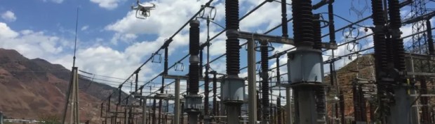
Lines, insulators, and substation equipment documented at a safe distance, with detail a ground survey can’t reach. See our utility industry work.
Industrial facilities
Tanks, stacks, conveyors, and structures across a plant, captured without scaffolding or a confined-space permit.
Bridges & structures
Undersides, spans, and hard-to-access structural elements documented for engineering review and condition records.
Findings your crew can work from
- 4K visual imagery of the full asset, close enough to read a cracked weld or a lifted fastener.
- Thermal imagery where it matters: trapped roof moisture, and dead cells or hot spots on solar.
- Located, annotated findings so your crew goes straight to the problem instead of hunting for it.
- Digital twins & 3D spatial models that turn subjective clipboard notes into objective, measurable 3D environments you can analyze year over year.
- A written inspection report in a format your engineers, roofers, or carrier already use.
- Insurance-ready documentation after a storm: dated, geotagged, and defensible.
- A repeatable baseline so a slow problem shows up as a trend across visits, not a surprise.
Commercial roof inspection near you, and anywhere we’re needed
Roofs are the asset we inspect most. Each Florida metro has its own page with the local detail; for a single roof or a portfolio outside Florida, contact us and we’ll scope the trip.
Have a site or an asset that needs documenting?Tell us the asset and the deadline. We’ll scope it and price it.
More of what we fly

Forensic 3D reality capture and multi-asset condition assessment in Tampa
The Challenge
A major industrial manufacturer needed a rigorous, site-wide condition assessment of their primary regional manufacturing and logistics hub in Tampa. The facility was a complex, multi-structure challenge: four 110-foot concrete storage silos, a sprawling operational building roof complex, and multiple overhead material handling conveyor gantries. Traditional methods, scaffolding or industrial rope access, were rejected over extreme occupational safety risk, a multi-week timeline, and projected seven-figure facility downtime costs. They needed engineering-grade data across all of it without sacrificing daily operations or personnel safety.
The Solution
We executed a precision forensic capture sequence across the entire complex. To close the gaps aerial data alone leaves behind, our flight operations were paired with a terrestrial scan, combining ground-level laser precision with macro-level aerial scope and eliminating the data shadows cast by the structures themselves. A multi-platform reality capture package generated the ultra-high-resolution colorized 3D point cloud shown here. Every millimeter of the complex geometry, including the concrete silo surfaces, the intricate conveyor lattice, and the rooftop penetrations, was documented, quantified, and geolocated.
The Result
The client’s engineering team completed a comprehensive remote virtual inspection from headquarters, removing working-at-height risk entirely. The combined aerial and terrestrial scans produced a zero-occlusion dataset that dropped straight into their existing engineering workflow. The 3D data documented, quantified, and geolocated the critical deficiencies: systematic corrosion on high-pressure conveyor support points, material buildup geocoded on gantry catwalks, and localized concrete cracking pinned for structural monitoring. We finished the multi-asset capture in two days of active flight time with zero facility downtime.
Drone inspection questions
What facility managers, engineers, and building owners ask us most about aerial inspections.
How is a drone inspection different from a traditional one?
A traditional inspection puts a person on a ladder, a lift, or a rope, which is slow, expensive, and the main reason inspections get skipped until something is already leaking. A drone holds a camera a few feet from the same asset and covers the whole thing in one flight, so you inspect more often, catch problems earlier, and nobody is exposed to a fall. For most commercial roofs, towers, and industrial structures the drone reaches places a ground crew simply can’t.
Do you offer thermal inspections, or just visual?
Both. Visual 4K covers cracks, corrosion, missing fasteners, and physical damage. Thermal adds a second layer: on a roof it finds trapped moisture under the membrane before it shows up as a stain, and on a solar array it flags dead cells and hot spots that a visual pass would miss entirely. We match the sensor to what you actually need to find out.
Can drone inspection reports be used for insurance claims?
Yes. After a storm, adjusters want dated, located evidence, and carriers increasingly want documented asset condition before they renew. We deliver time-stamped imagery tied to location plus a comprehensive written report and 3D digital twin of the asset, delivered in a format your carrier and public adjuster can both work from.
What about airspace and permissions?
That’s our job, not yours. Every flight is run by an FAA Part 107 certified pilot, and we handle the airspace authorizations nationwide, including sites near busy Class B and C airports. If a location can’t be flown legally, we tell you before the invoice, not after.
How quickly can you turn around an inspection?
A single asset is usually flown within a few business days of your call, with imagery and the report following shortly after. For a multi-site portfolio, whether across Florida or across the country, we route the flights together so you’re not booking one at a time. That matters most in the weeks after a hurricane, when Florida demand spikes statewide.
What kinds of assets do you inspect?
We run commercial drone inspection services across a wide range of asset types: commercial and industrial roofs, cell and communication towers, solar farms and rooftop arrays, utility infrastructure and substations, storage tanks, stacks, and hard-to-reach facility structures. If it’s tall, spread out, or dangerous to reach on foot, it’s usually a good candidate for a drone.
Get an asset inspected
Send the asset, the address, and what the inspection needs to answer. We’ll match it to the right sensor and a flight plan, and note anything about the site that would change the approach.
100 E Pine St, Suite 110 · Orlando, FL 32801
FAA Part 107 Certified · Fully Insured
Tell us the asset
Tell us a few details and we’ll get back within one business day.