
Drone utility inspection for solar, telecom, and grid assets
We run powerline inspection drone flights, tower inspections, and solar and substation work for the grid, the towers, and the arrays that keep the lights and the signal on, without an outage. Thermal, LiDAR, and high-density visual sensors capture the fault, the clearance, and the corridor in a single flight, so your team acts on data instead of a climb.
The assets that run the state are the worst ones to climb
A transmission line runs for miles. A cell tower is two hundred feet of steel. A utility-scale solar field is a sea of panels, and a substation is energized every second of the day. These are exactly the assets a utility director or a telecom asset manager needs inspected often, and exactly the ones that are slow, expensive, and dangerous to reach the traditional way.
A drone changes the math. It reads the conductor, the antenna, or the array from a safe standoff, in service, without a bucket truck or a climbing crew. What used to be a scheduled outage and a safety plan becomes a single flight, which means you can afford to inspect on a real cycle instead of only after something fails.
We see this nationwide, and Florida raises the stakes locally: it’s one of the fastest-growing solar markets in the country, its grid takes a hurricane season every year, and its telecom footprint keeps expanding. We fly all of it, from a single substation to a multi-state transmission corridor or a nationwide portfolio.

Grid, tower, and array assets, nationwide
Each asset class needs a different sensor and flight plan. We match both to the structure and to the condition you need to prove.
Cell & communication towers
Drone cell tower inspection reaches antennas, mounts, welds, and connections up close without a climber, and without taking the site offline. See our telecom industry work.
Solar farms & PV arrays
Solar panel inspection drone flights use thermal to flag hot cells, failed diodes, and dead strings across hundreds of thousands of panels in one mapped pass.
Transmission & distribution
A powerline inspection drone reads conductors, insulators, splices, and hardware live, with a LiDAR model of the whole corridor. See our utility industry work.
Pipeline & right-of-way inspection
Drone pipeline inspection flies the route for exposed pipe, erosion, and encroachment, with the same thermal and LiDAR corridor mapping we run on a transmission line applied to a pipeline right-of-way. See our utility industry work.
Substations
Transformers, bushings, and switchgear scanned with thermal and visual at a safe distance from energized gear.
Vegetation & encroachment
LiDAR separates ground, wire, and canopy to measure exactly where growth is entering the right-of-way.
Renewable & energy sites
Wind, storage, and generation assets documented for condition, warranty, and performance review.
Joint-use pole & attachment surveys
Every attacher on the pole, height on attachment, cable type, and messenger measured directly from the point cloud.
Pole loading analysis
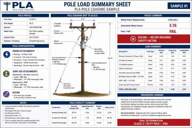
Point cloud geometry and attachment loads run against NESC safety factor requirements, pole by pole, before a new attachment goes on.
Findings and models your operations team can act on
- Thermal fault detection on PV arrays and substations: hot cells, failed diodes, and overheating connections.
- High-resolution visual of towers, conductors, insulators, and hardware, close enough to read a corroded splice.
- LiDAR corridor models that measure clearances and flag right-of-way encroachment.
- Digital twins & 3D spatial models that turn a climb-and-clipboard inspection into a measurable environment you analyze year over year.
- Dated, located records that stand up as compliance documentation and a baseline for the next cycle.
- No outage, no climber, so the asset stays in service while it’s inspected.

Real deliverables, not stock renders
A sample of what comes back from a corridor flight: joint-use attachment mapping, a pole loading safety-factor report, and vegetation clearance measured from the point cloud.


Have a site or an asset that needs documenting?Tell us the asset and the deadline. We’ll scope it and price it.
Related services
This vertical draws on our inspection and mapping work. If your assets are more structural or you need survey-grade site data, start there.
Solar, utility, and telecom inspection questions
What utility directors, telecom asset managers, and energy operators ask us most.
Can you inspect energized assets without a shutdown?
That’s the point. A drone reads a live conductor, an energized substation, or an in-service cell tower from a safe standoff distance, so you get the inspection without a truck roll, a climber, or an outage. For a utility or a carrier, keeping the asset in service while it’s inspected is most of the value.
How does thermal find problems on a solar farm?
A thermal payload flies the array and flags what a visual pass can’t: hot cells, failed diodes, cracked modules, and dead or underperforming strings show up as heat signatures. Across a utility-scale field of hundreds of thousands of panels, that turns a job that would take a crew weeks with a handheld camera into a single mapped flight.
What do you deliver on a transmission or distribution line?
High-resolution imagery of conductors, insulators, splices, and hardware, plus a LiDAR point cloud that measures clearances and models the corridor in 3D. That combination flags a corroded connection or a failing insulator and measures where vegetation is encroaching on the right-of-way, in one dataset.
Can you handle vegetation management and encroachment?
Yes. LiDAR captures the ground, the wires, and the canopy as separate layers, so we can measure exactly where trees are growing into the clearance envelope along a corridor. You get a prioritized encroachment map instead of a crew walking miles of line to guess at it.
Do you inspect pipelines and pipeline rights-of-way?
Yes. A drone flight covers the corridor for exposed pipe, erosion, and encroachment, and the same LiDAR and thermal payloads we use on transmission lines map where vegetation is entering the right-of-way. It’s the same corridor-inspection approach, applied to a pipeline route instead of a power line.
What about airspace around substations, towers, and grid infrastructure?
We handle it. Every flight is run by an FAA Part 107 certified pilot, and we clear the authorizations nationwide, including sites near busy Class B and C airspace. Utility and telecom sites are often in sensitive locations, so the flight planning is part of what you’re paying for.
Do the deliverables support compliance and asset records?
Yes. Everything is dated, located, and archived, so the inspection becomes a defensible record and a baseline for the next cycle. Paired with a 3D digital twin of the asset, your team can compare condition year over year instead of starting from a blank clipboard each time.
Get grid, tower, or array assets inspected
Tell us the asset and the location, a solar field, a tower portfolio, a substation, or a line corridor, and what condition you need documented. We come back with the right sensors, a flight plan, and a price.
100 E Pine St, Suite 110 · Orlando, FL 32801
FAA Part 107 Certified · Fully Insured
Tell us the asset
A few details and we’ll get back within one business day.