
Aerial Inspection for the Grid and the Assets Behind It
Transmission and distribution audits, radiometric substation thermal, solar array performance scans, and storm damage assessment. Flown without de-energizing the line and without putting a climber on the structure.

Most outages start somewhere nobody looked recently
A failing splice, a cracked insulator, a limb growing into a conductor. None of it announces itself, and all of it sits on assets that are expensive to reach, spread across miles, and energized. So inspection gets scheduled around outages and helicopter budgets instead of around risk.
Flying the corridor changes what’s affordable to look at. A sensor holds position a few feet from the hardware while the line stays energized, and the same pass returns both a visual record and a thermal one. You end up inspecting more often, and you find the problem while it’s still a work order instead of an event.
Florida sharpens all of it. Salt air corrodes hardware on both coasts, the summer load peaks exactly when the heat makes weak connections fail, and hurricane season turns inspection into damage assessment overnight. We fly single substations and we fly multi-county corridors.

Where drones actually earn their place on a utility system
Different assets need different sensors. Here is the work, and the service page behind each one if you want the detail on how we scope and fly it.
Transmission & distribution audits
Mechanical strain, insulator damage, corrosion, and hardware condition along the right of way, captured without dropping the line.
Substation thermal inspection
Calibrated radiometric thermal finds hotspots, loaded transformers, and degrading connections before they show up as a trip.
Solar array performance scans
Thermal across a multi-megawatt site isolates dead strings, cracked cells, and inverter faults far faster than a handheld walk of the array.
Vegetation and encroachment mapping
LiDAR returns ground, wire, and canopy as separate layers, so clearance is measured rather than eyeballed from a truck.
Storm hardening and post-event survey
Pre-season vulnerability assessment, then rapid damage capture across grid miles when you need to know where the crews go first.
Digital twins of critical sites
A colorized point cloud of a substation or switchyard your engineers can measure and inspect from their desks, revisited as the site changes.
Joint-use pole & attachment surveys
Every attacher on the pole, height on attachment, cable type, and messenger measured directly from the point cloud, not paced off with a rod.
Pole loading analysis
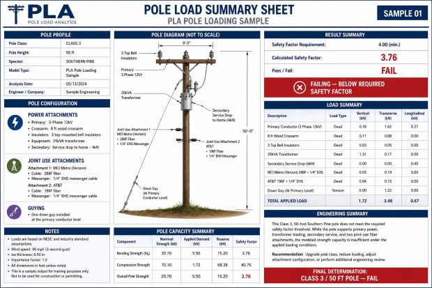
Point cloud geometry and attachment loads run against NESC safety factor requirements, pole by pole, so a make-ready decision has a number behind it instead of a guess.
What the data actually changes
- Fewer surprise outages. Thermal and visual anomalies get caught on a schedule instead of during a fault.
- Defensible vegetation management. Measured clearances from a LiDAR surface, not an estimate from the road.
- Nobody climbs. High-voltage structures get audited from the air, which takes the fall risk off the table entirely.
- Faster restoration. After a storm, one flight covers what a ground crew would spend a day driving.
- Records that survive an audit. Dated, geolocated evidence of condition, ready for a regulator or an insurer.
- Portfolios stay consistent. One operator across every substation and corridor, so the data compares year over year.
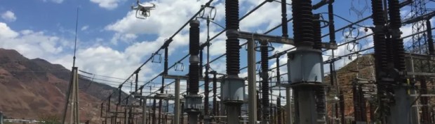
Real deliverables, not stock renders
A sample of what comes back from a corridor flight: attachment mapping, the corridor capture itself, and a pole loading safety-factor report.


Have a site or an asset that needs documenting?Tell us the asset and the deadline. We’ll scope it and price it.
Formats your engineers and GIS team already open
We deliver into your workflow rather than a proprietary portal. Tell us the software and the coordinate system before we fly.
Radiometric thermal
Georeferenced thermal TIFFs with retained temperature data, not screenshots of a thermal display.
Point clouds
LAS and E57 for structural modeling, clearance analysis, and as-built comparison.
GIS layers
Vegetation and encroachment layers that drop into ESRI ArcGIS or QGIS without conversion.
Priority-ranked findings
A defect report ordered by severity and pinned to coordinates, so crews get a work list.
Visual records
High-resolution stills indexed by structure number and asset ID.
Comparison sets
Repeat flights framed identically, so year-over-year change is obvious at a glance.
Pole loading & attachment reports
NESC safety-factor calculations and height-on-attachment data for every joint-use pole surveyed, ready to hand to make-ready engineering.
The services behind this work
Utility and energy inspection questions
What reliability engineers, asset managers, and solar operators ask us before the first flight.
Do we’ve to de-energize the line for you to fly it?
No. That’s most of the point. We fly at a standoff distance appropriate to the voltage class and capture the hardware while the circuit stays in service, so you’re not buying an outage to buy an inspection. If a specific capture genuinely needs the line down, we’ll tell you that during scoping rather than after.
Is your thermal calibrated, or is it a false-color camera?
Radiometric, which means every pixel retains an actual temperature value. You can open the file later and measure a delta rather than squint at a color ramp. That distinction matters when you’re arguing that a connection is 40 degrees over ambient and needs to be scheduled.
How do you handle airspace near substations and along corridors?
We hold the FAA Part 107 certification and we clear the authorizations before mobilizing, including controlled airspace around Florida’s larger airports. Corridors that cross multiple jurisdictions get sorted out in planning, not on the day.
Can you cover a whole service territory, or just one site?
Both, and the economics favor the larger program. Routing a set of substations or a run of corridor into one mobilization costs far less per asset than booking them individually, and the data stays consistent because the same operator and the same flight parameters are used throughout.
What happens after a hurricane?
Damage assessment becomes the priority and speed matters more than polish. We fly the corridor, get you located imagery of what failed and where, and hand it over in a form your dispatchers can act on the same day. Existing program clients get scheduled first, which is worth knowing before the season starts.
Will this integrate with the asset management system we already use?
Yes, provided you tell us what it is. We deliver georeferenced files in standard formats and tag findings to your asset IDs and structure numbers where you provide them, so the output lands in your system instead of sitting in a folder somebody has to re-key.
Put a flight program around your grid assets
Send the asset list, the territory, and how often you need it flown. We’ll come back with a schedule, the sensors we’d use, and what it costs per asset.
100 E Pine St, Suite 110 · Orlando, FL 32801
FAA Part 107 Certified · Fully Insured
Scope a utility inspection
Tell us the assets and the territory and we’ll come back with a plan.